13 June: The Grand Canyon
We didn't get going until late this morning as we had to check-
in at
the
campsite,
go food
shopping
and get
maps from
the
visitor's
centre.
Once all
that was
done we
set off to
discover
the Grand
Canyon.
We
decided
to
walk
the
South
Rim
of the
Canyon
between
Maswik
Lodge and
Hermits
Rest, a
12km
walk. The
trail
followed
the rim of
the canyon
and the
views were
spectacular.
The
trail
was
relatively
quiet,
despite
the heavy
affuence
in the
park.
T
here
were a
dozen
lookout
points
along
the
way plus
9 bus
stops for
the park's
shuttle
service,
where
the
lazy
tourists
descended to
effortlessly
view the
canyon.
The first
official
lookout
was at
Trial
Overlook
where
we
could
see
lots
of
hikers
and
donkeys
taking
the
Bright
Angel
Trailhead
down
into
the
canyon. We
would have
loved to
have
walked
down
to
the
Colorado
River and
back, but
it's a
difficult
2-day hike
not
suitable
for
children.
Maybe next
time...!
We ate our picnic lunch near Maricopa Point and marvelled at the
awesome
views over
the
canyon,
which is a
staggering
446km long
and
an
average
16km
wide. The
canyon is
approximately 6
million
years
old,
but
the
walls
of
the
canyon
are
made
of
rocks
dating
from
150
million
years to
an amazing
2 billion
years
old!
As we
walked we
began to
get views
of the
Colorado
river,
over
a
thousand
metres
below us.
The sheer
size of
the Grand
Canyon
is
breathtaking!
The girls began to tire as we approached the end of the trial so
we took a
shuttle
bus for
the
2.7km segment
between
Monument
Creek
Vista and
Pima
Point,
leaving a
further
kilometre
or so by
foot
to
Hermit's
Rest. The
Santa Fe
railway
had built
a refuge
at
Hermit's
Rest
in
the
early
1900's
to
act as
a
tourist
rest
place. It
has a
lovely,
huge
arched
fireplace
in
it's
main
room. Back
at
the NP
campground
we
had our
first BBQ
since we'd
left
Australia...!
 |
 |
 |
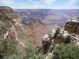
| Our first
sighting
of
the
Grand
Canyon! |
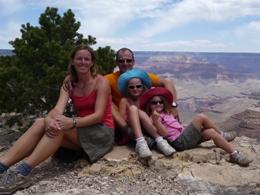
Along the
South
Rim
walk |
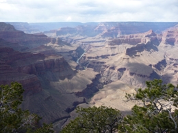
The Colorado
River
just
visible
in
the
depths
of
the
canyon |
14 June: Grand Canyon to Mt Carmel Junction
We were up early this morning for a 8:30 helicopter flight over
the Grand
Canyon. We
saw a
couple of
elk in the
middle of
the road
on
the way
to
the
airport.
The flight
began over
the forest
and then
crossed
the South
Rim, via a
subsidiary
canyon, to
the North
Rim and
beyond.
We
flew
nearly
50kms:
it was
amazing!
The views
of
the
canyon were
stunning
and we
could
begin to
appreciate first-
hand
the sheer
size of
the
canyon.
Afterwards we followed the Desert View Drive eastbound, stopping
off at a
couple of
lookouts,
the
Tusayan
Museum and
Desert
View.
The
Tusayan
Museum and
adjacent
ruins
were interesting
to gain
a
little
insight
into the
former
native
inhabitants,
the
Anasazi.
The
watch
tower
at
Desert
View was
also fun
to climb
and it was
interesting
to see the
petroglyphs
and
paintings
of the old
American
Indian
civilisations.
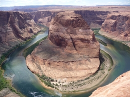
On our route towards Zion National Park we stopped at the
breathtaking
Horseshoe
Bend in
the
Colorado
River.
It's a 15
minute
walk across
an orange
sandy hill
to the
edge of
the canyon
from where
there's an
awesome
view of
the
Colorado
River
which has
carved
a
horseshoe
shaped
path
through
the
surrounding
rocks.
The beauty
of the
site just
takes your
breath
away as
you
stand
on
the
sheer
edged canyon
rim
overlooking
the river
by a
good
400
metres!
We also stopped off at a couple of lookout points to admire Lake
Powell,
created
by a
dam built
in 1957,
before
arriving
at
Carmel
Junction
at around
20:20 (we
lost an
hour
travelling
from
Page
on
the
edge
of
Lake
Powell
in
Arizona
to
the
State
of
Utah).
The
campsite
isn't
luxurious,
it's
situated
just
metres
away from
the
highway,
but the
staff
are
friendly:
they even
lent us a
BBQ!
It's a
shame that
in the US
we don't
find the
brilliant
Aussie
outdoor
facilities;
no
playgrounds
in the
campsites,
very few picnic
areas, no
BBQs,
etc...
 |
 |
 |
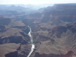
| A bird's eye
view
of
the
canyon
from
the
helicopter |
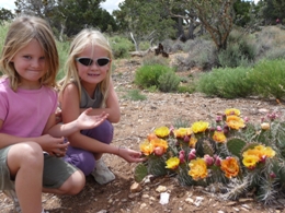
Cactus in
full
bloom |
The
spectacular
Horseshoe
Bend
of
the
Colorado
River
in
the
Grand
Canyon |
15 June: Zion National Park
We headed for Zion National Park today. We had to get a ranger
convoy
through a
tunnel in
the park,
mandatory
for all
large
vehicles,
so that
two-way
traffic
could be
stopped
enabling
us
to
drive
through
the centre
of the
tunnel!
The rocks
on
the
east
side
of
Zion
park are
spectacular:
the
colours
vary from
white
to
orange to
red and
the
geographical
layers of
rock
criss-cross
spectacularly.
We took a
shuttle
bus at the
visitor's
centre to
Zion
Lodge
for
the
Emerald
Pools
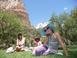
trail. We
ate a
picnic
lunch on a
lovely
grassy
area in
front of
the
Zion Lodge
before
beginning
the
hike.
There are
3 pools
along the
walk
formed by
rain water
seeping
through
the rocks
over
hundreds,
even
thousands
of years.
The
waters
are
green
due
to
algae
and
swimming
is
forbidden
due to the
presence
of
bacteria
in
the
pools.
The
girls
had
therefore
to
settle
for a
paddle in
the upper
pool.
Next we took the shuttle to the end of Zion Canyon to Sanawana
Temple.
We
did a
short
walk,
called the
Riverside
Walk, up
the canyon
to the
Narrows.
From this
point i
t's
only
possible
to
continue
up
the canyon by
foot
in
the
river.
We
saw lots
of wet
people
wadding up
and down
the river
which is
up to
waist
height in
water in
some
places. If
it'd been
calmer
we'd
probably
have
attempted
the
ascent,
but there
were so
many
tourists
wadding along
the river
we weren't
motivated
to
join
the
masses
in
getting
our hiking
boots
soaked.
We took the shuttle back down the canyon stopping at Big
Bend to
take
a few
photos. We
also
stopped at
Weeping
Rock
to
walk up
a
trail to
a
rock
where
rain
water
between
800 and
1200
years
old
permanently
weeps
through
the
rock.
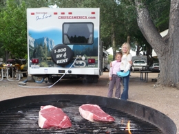
Back at the RV park, we grilled some succulent steaks
on
the barbeque and
planned
our route
for the
days to
come.
 |
 |
 |
| Picnic at Zion
Lodge |
Along the
Emerald
Pools
trail |
Steaks on the
BBQ! |
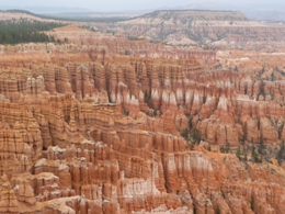
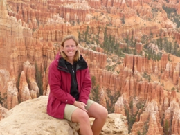
16 June: Bryce Canyon National Park
We got up early to drive to Bryce Canyon National Park, through
the scenic
Red
Canyon. It
was
unfortunately
overcast
this
morning
and a
50% chance
of rain
was
forecast.
We packed
our
goretex
jackets in
the
rucksack
and set
off
for a
3
mile
walk
along
Navajo
and
Queens
Garden
trail. The
hoodoos,
the
amazing
rock
columns, in the
park are
spectacular
and the
area
covered by
these
beautiful towering
towers is
staggering;
the park
is about
20
miles
long! We
walked
down a
steep
track,
through a
tunnel in the
rocks to
the bottom
of the
canyon to
get to the
base of
the
hoodoos.
The
colours
are
stunning:
deep
oranges,
reds,
whites, yellows and
browns.
The
scenery in
this park
is really
beautiful.
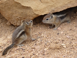
We saw three small
golden-mantled
ground
squirrels
hiding in
the rocks
on the edge of
the
track.
It started to rain a little as we ate lunch in the
campervan,
but
we headed
out
nevertheless
for a second walk
along the
rim trail
from
Inspiration
Point to
Bryce Point. From the
rim of the
canyon we
could
really
appreciate
the magnitude of the
hoodoos.
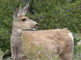
We saw a
mule deer
grazing on
the side
of the track.
It began to rain more persistently so we drove the RV to the end
of the
canyon and
stopped at
all the
scenic
lookouts on the return
journey.
We decided
to put the
rainy
weather to
good use and stopped at
Ruby's
campground
to do our
laundry
and catch up with some Internet.
We stayed
the
night at
a RV park
just outside Red Canyon.
 |
 |
 |
| Along the
Navajo
and
Queens
Garden
trail |
View from the
rim
between
Sunrise
and
Sunset
Point |
Golden-mantled
ground
squirrels at
Bryce
Canyon! |
 |
 |
 |
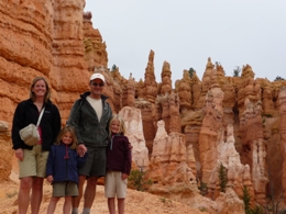
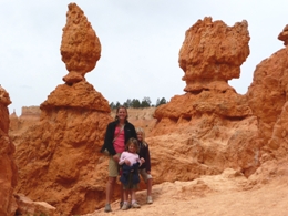
| The girls and
the
flame
shaped hoodoos |
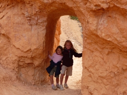
A rock tunnel
on
the
track |
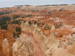
The vastness
of
Bryce
Canyon |
 |
 |
 |
| A mule deer
(what
big
ears it's got!) |
Jenny
surrounded
by
hoodoos! |
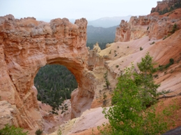
A huge arch
called
Natural
Bridge in Bryce Canyon - a taste for what's in
store
at Arches
NP! |

BACK
|